Too close for comfort
Published 9:10 pm Wednesday, October 2, 2019
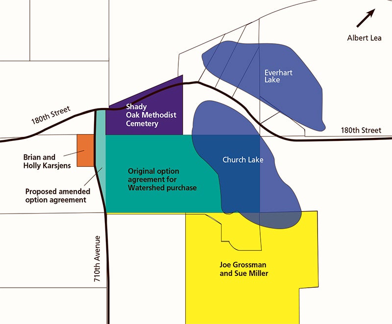
- Surrounding landowners met with Shell Rock River Watershed District representatives Sept. 23 to discuss concerns over future use of land the district intends to purchase. Concerns include public hunting near residential and private properties, dumping and trespassing. Graphic by Kim Ehrich/Albert Lea Tribune
Safety a concern if private land becomes open to public
Should a specific vote move forward Tuesday at the Shell Rock River Watershed District meeting, Holly Karsjens has a very specific concern: namely, how many feet stand between her home and would-be public land on which hunting could be allowed.
Measured end-to-end with a tape measure and including the 25-foot-wide 710th Avenue, it is about 105 feet.
Right now, an approximately 80-acre rectangle is already part of an option to purchase agreement between a private owner and the Shell Rock River Watershed District. The Watershed District board is scheduled to vote Tuesday as to whether that agreement can be amended to add an approximately 6- to 7-acre sliver of land on the west edge — the same side the Karsjens live on — intended to increase public access to the land.
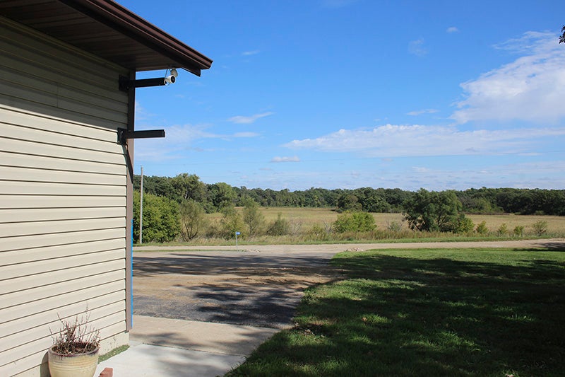
Holly Karsjens’ garage is 105 feet from the edge of what could become public land open for hunting should the Watershed District purchase it and then hand it off to the Department of Natural Resources as expected. Sarah Kocher/Albert Lea Tribune
The vote was postponed after board managers unanimously voted to do so in September, citing a need to speak further with citizens who called with concerns.
Approximately 20 of those concerned citizens showed up to a Sept. 23 meeting instigated by area landowners. Watershed District Administrator Andy Henschel, Karsjens and Sue Miller, whose property directly abuts the land in the current option agreement, all said most landowners surrounding the parcel were represented.
Funding for the purchase, engineering, wetland enhancements, contract work and native vegetation planting — approximately $800,000, Henschel said — came from the Lessard-Sams Outdoor Heritage Council. The primary intention for the property is improvements, enhancements and protection of the wetlands and oak savanna on the property. What is currently farmland would be turned into an upland prairie habitat seeded with a native mix or possibly a pollinator mix, Henschel said. He said the project is just in its beginning phases.
But it is what comes after that landowners find issue with. After the Watershed District makes improvements on the property, it plans to turn that property over to the Department of Natural Resources. DNR Area Wildlife Manager Jeanine Vorland said the timeline for that handoff is unclear.
At that time, it would become a wildlife management area: state-managed land whose principal purpose is to provide habitat for indigenous Minnesota wildlife. This land also provides opportunities for “wildlife-based outdoor recreation,” Vorland said. This could mean birdwatching, enjoying native plants, trapping or hunting.
This is where those 105 feet begin to make Karsjens feel very worried.
“We’re close enough to hold hands, almost, around the lake,” she said of her fellow surrounding landowners.
What about buffers?
The DNR’s 2019 hunting and trapping regulations state that a person may hunt from public land or the water — which, in Minnesota, is also public — within 500 feet of a building occupied by humans or livestock. If you are hunting on another person’s private land or a public right-of-way, you cannot do this without written permission from the owner.
The lack of buffer between living space and hunting space is a concern for both Karsjens and Miller.
Watershed District board manager Dan DeBoer attended the township meeting. He said concerns with hunting and dumping are not the Watershed District’s issue, and that the district is focused on clean water.
“That’s not our goal … to have hunting land,” he said. “Our goal is to have clean water.”
He said the meeting was an opportunity for the public to speak to their concerns, and that he believes those concerns were addressed at the meeting.
“I feel like the theory that this is not, there’s not a safety issue or we shouldn’t be concerned, I think it’s absolutely bogus,” Karsjens said. “They’re not the ones out here trying to have coffee on their front porch and there’s people that they don’t know with guns 100 feet away.”
Henschel said that after the meeting, he talked with the DNR about possibly putting in buffers along the houses, and that there was potential for that.
There are some instances in which the DNR has instigated buffers on public land, Vorland said. However, the DNR tends to wait to see if there will be an issue before doing so. That is the case for Church Lake.
“At this time, we’re gonna wait and see,” Vorland said.
Henschel said something regarding concerns about land use could be figured out before the transfer from the district to the DNR.
Trash, trespassing and access
Both Karsjens and Miller called their home the same thing: a sanctuary.
“We’ve built up our life out there in a very private area,” Miller said.
She said her family worked hard to restore and protect the natural resources on their own property, and they believe in creating good habitat and improving water quality. The potential for public hunting makes her scared, disappointed and sad, she said. Right now, she sends her grandchildren up her long driveway that abuts the south side of the Watershed-acquired property to get their mail.
“I wouldn’t feel safe letting them walk down the driveway with the dogs at all,” Miller said.
Karsjens said she grew up next to public land and her parents still live next to it. After a big hunting weekend, she and her mother fill trash bags of bottles, McDonald’s breakfast sandwich garbage and shell boxes. People dump their trash. They turn around in her parents’ driveway.
“Signage is for people that read the signs,” Karsjens said. “I’m not worried about the people hunting that read the signs. … I’m concerned about the ones that I have stories about from childhood.”
Gary Rogert, treasurer of the Shady Oak Methodist Cemetery to the north of the Church Lake purchase, is worried about trespassing as well as safety. The cemetery already has problems with it — largely with vandalism, he said — and should the land to the south of the cemetery become public, he said he sees parking in the cemetery as one of the easiest points of access for hunters. The proposed addition of 6 or 7 acres on the west side would ask hunters to travel across a long slough of wet cattails before reaching the lake on the eastern half of the property. He said he doesn’t see people choosing that.
However, he said he also does not see a way for people to access Church Lake’s public waters as is, surrounded by private properties, and he doesn’t see landowners granting that access to hunters.
Signs denoting boundaries are spaced at a maximum of 500-foot intervals in Wildlife Management areas, Vorland said.
Public land use
There are almost 2,747 acres of Wildlife Management Area in Freeborn County, according to DNR information officer Dan Ruiter. In combination with other publicly owned lands managed by the DNR, that number becomes approximately 1% of all lands in Freeborn County, Ruiter said.
Vorland said it is not uncommon for people to live near Wildlife Management areas.
Complaints of unsafe public land use that come through Vorland’s office do happen, but not frequently.
“As far as the unsafe use, that’s a very rare call,” she said.
She will also get occasional calls about dumping and disrespect for public lands.
Local DNR Conservation Officer Jeremy Henke denied requests for an interview, saying in an email he was “not able to assist any further.” He said the biggest complaint he gets from people using public land is that there is not enough of it.
The biggest use of public land is hunting, Vorland said. In the Albert Lea area, the second-most frequent use is wildlife viewing. Land use tends to pick up in the late fall and die off through the winter.
How frequently the Wildlife Management areas are visited by DNR staff depends on how much “babysitting” they need, Vorland said. Some are visited monthly, while some could go longer. Those with fewer “unsavory use” problems are visited less frequently.
The reason for these areas of public land is because not everyone is fortunate enough to have easy access to conservation lands, Vorland said.
“It’s our way of providing access to the outdoors for everybody,” she said.
But Miller also has concerns about the land’s long-term stewardship. More land acquired as public takes more resources to manage and maintain, and the DNR has limited staff and resources to take care of these properties, she said.
For Miller, a good outcome is for the Watershed District to reconsider the acquisition and return to Lessard-Sams, asking for a reallocation of funds dedicated to this project. The property is already protected by the Minnesota Wetland Conservation Act and Freeborn County’s Shoreland ordinance, she said.
Both Miller and Karsjens expressed concerns about the transparency of the process, too. Though decisions to enter the option agreements were on the public agendas, Karsjens said there was no effort made to notify surrounding landowners of the change of use, though the Watershed District is not required to do so. She said she wants to see a check and balance for Watershed District land acquisitions moving forward.
“If you’re gonna build a racetrack, don’t you want to ask your neighbors if they’re OK with loud cars?” Karsjens said.
Miller said she was concerned the process got as far as it did without anyone knowing. She caught it while going through the September agenda for the Watershed District meeting, which she receives as part of her job with the county.
Karsjens said she gets the feeling the racetrack is coming, and she will have to get comfortable around loud cars.

More News

-
Construction Updates
-
-